


Planning
Can I build a balcony/roof garden on my extension without permission?
No - specifically excluded from exemption by Part 1, Schedule 2, Column 2, Condition 7. (see page 156).
Can I erect a Wind Turbine, Solar Panel, Heat Pump within the curtilage of my house?
Yes. From 28/02/2007 these are exempted under new Class 2 to exempted regulations, subject to limitations.
The Planning and Development (Amendment) Regulations 2007 give effect to exempted development provisions in respect of renewable energies for dwellings and refer to the installation or erection of a solar panel on or within the curtilage of a house, or on any buildings within the curtilage of a house is exempt subject to compliance with the following conditions and limitations:
Solar Panels:
The installation of solar panels on domestic properties is now exempt from planning permission . Since the 7th of October 2022, there is no longer a limit to the area of solar panels which can be installed on rooftops of homes .The 12sqm or 50% roof limit which previously applied to houses has been removed nationwide .
There are still some rules that apply .It is advisable to check with the local authority if ; .
- Your home or building is a protected structure.
- Your home or building is located in a protected area , for example in an architectural conservation area .
- Your home or building lies near an aviation site.
For more information please click Here
Wind Turbines:
The construction, erection or placing within the curtilage of a house of a wind turbine is exempt subject to the following Regulations (Class 2)
1. The turbine shall not be erected on or within the curtilage of a house of a wind attached to the house or any building or other structure within its curtilage.
2. The total height of the turbine shall not exceed 13 metres.
3. The rotor diameter shall not exceed 6 metres.
4. The minimum clearance between the lower tip of the rotor and ground level shall not be less than 3 metres.
5. The supporting tower shall be a distance of not less than the total structure height (including the blade of the turbine at the highest point of its arc) plus one metre from any party boundary.
6. Noise levels must not exceed 43db(A) during normal operation, or in excess of 5db(A) above the background noise, whichever is greater, as measured from the nearest neighbouring inhabited dwelling.
7. No more than one turbine shall be erected within the curtilage of a house.
8. No such structure shall be constructed, erected or placed forward of the front wall of a house.
9. All turbine components shall have a matt, non-reflective finish and the blade shall be made of material that does not deflect telecommunication signals.
10. No sign, advertisement or object, not required for the functioning or safety of the turbine shall be attached to or exhibited on the wind turbine.
FYI - The Planning and Development (Amendment) Regulations 2008 (SI 256 of 2008) give effect to exempted development provisions in respect of renewable energies for industrial buildings, business premises and agricultural holdings.
Please refer to Regulations for further information.
How many vacant sites are registered with dlrcoco?
There are currently 12 sites registered as vacant with dlrcoco. Please see the the full list here.
What is a Local Area Plan?
A Local Area Plan (LAP) is a statutory document prepared by the Local Authority in accordance with the requirements of the Planning and Development Act 2000 (as amended). A LAP consists of a suite of policies and objectives to guide the development of an area for a period of 6 years.
A LAP sets out a land use strategy for the proper planning and sustainable development an area and consists of a written statement and maps indicating:
- objectives for the zoning of land for the use solely or primarily of particular areas for particular purposes, or
- other objectives in such detail as may be determined by the Planning Authority for the proper planning and sustainable development of the area to which it applies, including the objective of development of land on a phased basis and, detail on community facilities and amenities and on standards for the design of developments and structures.
Can I build a garden shed on my property without permission?
Yes provided that:
- It is not forward of the front wall of the house;
- Not greater than 30sqm total area (not floor area) (or no. of sheds aggregated);
- 25sqm of garden space is left. N.B. extensions attached to house are not reckoned as private open space;
- Shed finish is in keeping with the house;
- Shed height: max 4m pitched roof; 3m flat roof;
- It is not lived in or used for keeping of animals (pigs, ponies, horses, pigeons).
Is permission needed for a crèche childcare facility?
Yes, unless the number of children, including carers is not more than 6 and caring is in carers own house.
Will there be information sessions?
Yes, there will be two public information sessions in St. Gerard's School, Thornhill Road on:
- Thursday, 18th of May from 4:00pm - 8:00pm
- Monday, 29th of May from 4:00pm - 8:00pm.
Can I build a porch without permission?
Yes, provided that:
- Not less than 2 metres from roadway;
- Not more than 2sqm Height: 3m max for a Flat Roof, 4m max Pitched Roof.
(see page 158, Class 7)
Do Statutory Undertakers need permission for routine works in the provision/maintenance/overall of their facilities (e.g. Local Authorities, ESB, Telecoms, Iarnrod Eireann, Bord Gais, etc.)?
Generally, No. Refer to exempted development regulations for limitations.
(Page 163).
Can I build an extension to the side of my house?
No. Not as exempted development. However an existing garage to the side may be converted (see Section 6).
Does the Council need permission to do its own work?
No, not in the normal way, but, is subject to the consultation procedures contained in Part VIII of the 2001 Planning Regulations as amended.
Can I build an extension to the front of my house without permission?
No. This is not exempted development (except the porch - for exemptions see page 158, Class 7 and Section 9).
How long does an applicant have to lodge additional information?
6 months. From 31/03/2003 an additional 3 months can be granted where agreed.
Can I install a chimney, boiler house or oil tank for central heating without permission?
Yes. The capacity of oil tanks shall not exceed 3,500 litres (Page 156,Class 2).
Note: from 28.02.07 exemption widened to flue, fuel storage tank or structure. 3.5k capacity still applies.
Can I demolish a habitable home without permission?
No, you can demolish part of a habitable home to provide a domestic extension.
Can I erect a T.V. antenna on my roof without permission?
Yes. The height of the antenna shall be no more than 6m above the roof.
Note: These notes are for guidance only. The relevant Planning Regulations should always be consulted where doubt exists.
What is a Declaration and Referral on Development & Exempted Development (i.e. what is a Declaration of Exemption)?
If a query arises as to whether a proposal requires Planning Permission or whether it is exempted development, a submission may be made, in writing with proposals or maps - the more information the better accompanied by a fee (€80.00). The planner will consider submissions & we reply within 4 weeks as to whether it does require planning permission or not. The applicant can refer the decision to An Bord Pleanala accompanied by a fee (€150.00).
(Section 5, Planning & Development Act, pg 28)
What is a Local Area Plan
A Local Area Plan (LAP) is a statutory document prepared by the Local Authority in accordance with the requirements of the Planning and Development Act 2000 (as amended).
A LAP consists of a suite of policies and objectives to guide the development of an area for a period of 6 years. A LAP sets out a land use strategy for the proper planning and sustainable development an area and consists of a written statement and maps indicating:
- objectives for the zoning of land for the use solely or primarily of particular areas for particular purposes, or
- other objectives in such detail as may be determined by the Planning Authority for the proper planning and sustainable development of the area to which it applies, including the objective of development of land on a phased basis and, detail on community facilities and amenities and on standards for the design of developments and structures.
Can I erect a Satellite Dish without permission?
Yes provided that:
- Only 1 per house.
- Max. Diameter 1 metre.
- Not to be erected on, or forward to the front wall of the house.
- Not to be erected on the front roof slope or higher than the highest part of the roof.
(see page 157, Class 4, 1 - 4).
Can photocopies of maps be given out to the public?
Photocopies of maps on planning applications registered before 11-Mar-2002 cannot be issued. Any photocopies of maps on files registered after 11-Mar-2002 must be individually date stamped and a declaration under Section 74 (4) of the Copyright and related Rights Act, 2000 must be signed by the purchaser of the maps and placed on the planning file.
What is a Protected Structure?
Protected Structures are buildings, features and structures within Dún Laoghaire-Rathdown that are protected because they meet one or more of the Categories of Special Interest set out in Section 51 (1) of the Planning & Development Act, 2000 and Section 2.5.4 of the Architectural Heritage Protection Guidelines. These categories are Architectural, Historical, Archaeological, Artistic, Cultural, Scientific, Technical and Social.
The list containing all the structures that are protected within Dun Laoghaire Rathdown is known as the Record of Protected Structures (RPS). Prior to an Act in 1999 these buildings or features were known as Listed Buildings, but this title no longer applies. The RPS is a dynamic record to which structures continue to be added and sometimes deleted.
Can I build walls around my house without planning permission?
Yes, subject to:
- Not more than 2m high to the rear.
- Not more than 1.2 metres to the front or forward of the front of the house.
(Page 157, Class 5).
NB: Metal palisade or other security fencing is not exempt.
I have planning permission, how is this affected?
Planning permission has no impact on the need for a Disability Access Certificate. If the works began on a building (other than dwellings houses) on or after January 1st 2010, then the Disability Access Certificate is required.
Why are you adding a new structure to the RPS?
Section 54 of the Planning and Development Act, 2000 (as amended), states that a planning authority may add to or delete from its record of protected sturtures if it considers that an addition is necessary to protect a structure (or part of a structure) of special architectural, historical, archaeological, artistic, cultural, scientific, social or technical interest.
The Red Brick (former) Chapel is considered to be of:
- Architectural Interest
- Historical Interest, and
- Artisitc Interest.
Can I erect a gate within my property without permission?
Yes, subject to a maximum height of 2m.
(Page 157 Class 5, page159 Class 9)
What does a 'new or greater contravention' of the Building Regulations mean?
Material alterations or Extensions should not give rise to any ‘new or greater contravention’ in the existing building. That is, a material alteration or an extension (vertical or lateral) to an existing building should not make the existing building any worse in relation to Building Regulations.
The following examples are given by way of clarification:
The erection of an extension to an existing building whereby the extension is to be served for access and escape purposes by an existing staircase within the existing building:
• If the existing staircase was adequate for the occupancy capacity of the existing building but inadequate for the extended building, this would constitute a ‘new contravention’ of Building Regulations.
• If the existing staircase was inadequate for the existing building and rendered more inadequate due to the additional occupancy of the extended building, this would constitute a ‘greater contravention’ of Building Regulations.
Note, therefore, that Building Regulations as they apply to works in connection with existing buildings being materially altered or extended, require solely that the 'status quo' be maintained in the existing building. Where an existing building contravenes Building Regulations, the material alteration or extension of such a building does not carry with it the requirement to make good such contravention, but merely that the contravention is not worsened, i.e. that no new or greater contravention arises. Building Regulations do not apply retrospectively to existing buildings where such buildings are being extended except to the extent that any new or greater contravention is not permitted.
What are the fees at stage 1?
There are no fees at stage 1.
Can I provide car parking in my garden without permission?
Yes. To the front or side for not more than 2 cars.
(Page 157, Class 6, Part B(ii))
NB. The widening of vehicular entrances is not exempt. (3.5 meters max with permission)
Where the design of a building or work on a building is changed (eg: unforeseen site conditions demand layout changes), what is expected?
A revised Disability Access Certificate is required where significant revision is made to the design or works or a material alteration to or a material change of use of a building in respect of which a Disability Access Certificate has been granted by a Building Control Authority. You may apply to the Building Control Authority for the revised certificate.
What are the fees at stage 2?
The fee at stage to is €1,500,, that would be submitted through the planning portal.
Can I build an extension to my home without having to seek planning permission?
Broadly speaking, the construction of an extension or conservatory does not require planning permission when it is to the rear of the house; however, any query from the public of this nature should be dealt with subject to the provisions of Part 1 of the 2nd Schedule to the Planning and Development Regulations, 2001.
The following should be seen only as general guidelines:
- Terraced and Semi-Detached Houses: If the house has not been previously extended, the floor area of the proposed extension cannot exceed 45 sq metres. This exemption also allows for extensions above ground-floor level (if the house is semi-detached or terraced, the area of the above ground extension cannot exceed 12 sq. m). This means, for a typical semi-detached house, one could have a ground floor extension of 28sq. m & 2nd floor extension of 12sq m without applying for planning permission. Any above ground floor extension shall be a distance of not less than 2 metres from any party boundary.
- Detached Houses: As with terraced and Semi-detached above, the overall area of extension must be less than 45 sq. metres. This exemption also allows for extensions above ground floor level, the are above ground floor are cannot exceed 20 sq. m. One could therefore have a ground floor extension of 20 sq. m., and a 2nd floor of 20 sq. m. Any above ground floor extension shall be a distance of not less than 2 metres from any party boundary.
- Both Cases: If the proposed extension is in addition to an existing extension (post 01-10-1964), overall areas of all extensions must not be more than 45 sq. m. - including extensions which needed permission, e.g. to side of house.
Can I convert 2 or more dwelling to use as a single dwelling without permission?
Yes. But only if the structure was previously used as a single dwelling. e.g. a house which was used as a single dwelling when built, later converted to flats can convert back to single dwelling use under this exemption.
What options has the building owner where the application is refused or granted subject to conditions?
There is provision for an appeal to An Bord Pleanála in such cases. The appeal must be lodged within 1 month of the date of the decision on the application –see Part VI of the Building Control Regulations.
What are the fees at stage 1?
There are no fees at stage 1.
Can I cover my entire back garden with an extension of 40sqm?
No.
The extension shall not reduce the "Private Open Space" of the back garden to less than 25 sq. m. Hard surface areas to the rear of a house are exempted development, providing they are used for a purpose incidental to the enjoyment of the house and not used for the parking of cars.
N.B. Existing or proposed garden shed/s are not reckoned as private open space.
Does a For Sale sign on a dwelling need permission?
No, subject to:max area of 0.6sqm in case of a house/letting max area 1.2sqm in case of any other structure/land.
Not more than 1 sign. Remove not later than 7 days after sale/letting.
Note 2 requires a “certified” set of drawings. Who can ‘certify’ drawings?
It is expected that drawings will be certified by a person qualified to do so as a building professional- this would be expected to be the professional who completed the drawings.
What are the fees at stage 2?
The fee at stage two is €1,500, that would be submitted through the planning portal.
If I build an attic conversion do I need permission?
Class 1B of the Planning and Development Regulations 2001, as amended applies.
A dormer roof extension and insertion of a dormer window to the side or rear of the house.
Conditions and limitations:
- The internal volume of the development either singularly of in combination with other dormer roof extensions shall not exceed 30 cubic metres.
- The dormer extension shall be no higher that the roof ridge and there shall be at least a 20 centimeters eaves setback
Can I build a pond, path, decking or landscaping works without permission?
Yes. Provided that the ground level not be altered by more than 1 metre above or below the level of adjoining ground. Alteration of ground level to front of house is not permitted other than for landscaping.
(Class 6)
Will the building owner or a person so authorised sign the statutory declaration in respect of works for which a Regularisation cert is sought?
This is a matter between the building owner and the builder/professional engaged by the building owner.
What are the fees at stage 3?
The fees for stage 3 are as follows:
There is a charge of €130 per housing unit.
Other structures are charged at €7.20 per square metre to a max of €32,400
There is a retention charge of €390 per housing unit.
Other structures are have a retention charge of €15 per square metre to a max of €65,000
Submission of EIS at €10,000
Submission of NIS at €10,000
Is the area of an attic conversion reckonable in assessing the 45sqm exemption limit for domestic extensions?
No.
Can I paint my house without permission?
Yes, except for a mural and providing the house is not a Protected Structure.
(Page 159, Class 12)
What height can I build my extension without permission?
- The highest point to which the wall of an exempt extension can be built is eaves level.
- If the proposed extension has a flat roof, it must not exceed the eves or parapet level
- If the proposed extension has a pitched roof, it must not exceed the ridge of the existing pitched roof.
How can I find out further information about the mapping and submissions process?
If further information is required on the draft map process or on making a submission please check ‘Your Questions Answered’ which can be found here. If your query relates to a particular area of land or if the answer is not contained in the FAQ’s contact the Dun Laoghaire-Rathdown County Council Planning Department.
Further information on the process is also available in the ‘Residential Zoned Land Tax - Guidelines for Planning Authorities’.
As outlined above, the RZLT process has two parts. Local authorities are required to undertake the mapping which identifies the land which is subject to the tax, including an annual update of the final map which will be published on 1 December 2023. Thereafter, the administration of the tax will be undertaken by the Revenue Commissioners.
As Dun Laoghaire Rathdown County Council do not administer the tax we are unable to answer any queries regarding the administration of the tax. All queries regarding the administration of the tax should be directed to the Revenue Commissioners
Having regard to the respective roles of local authorities and the Revenue Commissioners in the RZLT process, queries on the mapping should be made to Dún Laoghaire-Rathdown. This includes queries on;
• Criteria for inclusion on Draft map
• Submissions on Draft Map
• Determinations on Draft Map
• Supplemental map
• Submissions on supplemental map
• Determinations on Supplemental map
• Zoning submissions
• Appeals (which must be submitted to An Bord Pleanála)
• Final map
• Annual revised Final map
Queries on administration of the tax should be made to the Revenue Commissioners website –This includes queries on;
• What constitutes a relevant site for the purpose of RZLT
• Liable persons
• Amount of residential zoned land tax
• Obligation to register
• Obligation on liable person to prepare and deliver return
• Abatements
• Deferral of residential zoned land tax
Can I convert my garage to living accommodation without permission?
Yes. Subject to the provisions of Part 1 of the 2nd Schedule to the Planning & Development Regulations 2001 N.B. Garage must be attached to the dwelling.
(Page 156 - 157).
Can I keep a caravan/campervan or boat in my garden without permission?
Yes, subject to:
- Not more than 1 caravan / campervan or boat;
- No commercial / advertising use;
- Not used as a dwelling while stored;
- Storage not greater than 9 months in any year.
(Page 158, Class 8)
If I wish to make a submission or observation on a Planning Application, when can I do so?
Use our Planning Deadline Calendar to calculate the last date for making an objection.
Submissions/observations must be made within 5 weeks beginning on the date of receipt of the planning application. The five week period commences on the day that a planning application is received, such that the last day for receipt for an objection to an application received on Tuesday 1 November is Monday 5 December. If the last day of this five week period falls on a Saturday, Sunday or Public Holiday, submissions/observations can be accepted on the next working day.
Please note that anyone other than the applicant can make an objection/observation on a planning application. A fee of €20 applies
For more information on the objections process please visit our Planning Objections Page
What do I do if I am a Homeowner?
My house and garden is contained on the map. What is the consequence?
Your house and garden is identified on the map because it meets the criteria for the tax, which is based on residential led zonings and servicing by infrastructure suitable for provision of housing. The house and garden are not liable for the tax, as long as the house is subject to Local Property Tax (LPT).
Do I need to make a submission?
While anyone may make a submission, it may not be necessary, as a home owner, to make a submission. Even if your house is identified on the maps, residences shall not be chargeable to the Residential Zoned Land Tax.
What if my garden is greater than 0.4047ha (1 acre)?
If your garden is greater than this size, then you need to register for the RZLT with the Revenue Commissioners, however your house and garden will not be liable for the tax. You will be able to register for RZLT from late 2023 onwards. No action needs to be taken to register at this time. Please see revenue.ie for details closer to the time.
County Development Plan
Why was my property not added to the RPS previously?
The surveys carried out by the Minister for Housing, Local Government and Heritage for part of the County were not fully completed prior to the adoption of the current County Development Plan 2016-2022.
When did the new Development Plan come into force?
The County Development Plan 2022-2028 was made / adopted, with amendments, by the elected members during Special County Development Plan meetings on the 9th and 10th March 2022.
Section (12) (17) of the Planning and Development Act, 2000 (as amended), states:
"A development plan made under this section shall have effect 6 weeks from the day that it is made."
The new plan came into force on the 21st April 2022.
Where can I view the proposed Variation to the County Development Plan?
Proposed Variation No.1 documents are available to view upon request at the following locations, during their normal opening hours:
- Planning Counter, County Hall, Dún Laoghaire (10.00am – 4.00pm)
- Council Offices, Dundrum Office Park, Dundrum (9.30am – 12.30pm & 1.30pm – 4.30pm)
- All branches of Dún Laoghaire-Rathdown Libraries during Library opening hours.
- Copies of the proposed variation and its associated maps and environmental reports are available to download and view on this webpage using the document list above.
What is a Development Plan?
In simple terms, a Development Plan is a spatial plan that guides the future development of a County for a six-year period through a suite of policy objectives, land use zoning objectives and development management guidance.
A Development Plan must ensure that there is enough land zoned in the County to meet our housing requirements which are set at a regional level. Chapter 1 of the Plan sets out more detail in relation to the legislative context and structure of the Development Plan.
A short video was prepared at the Draft Plan stage which provides an overview of what a Development Plan is and the vision for the County for the period 2022-2028 (note: the Draft Plan consultation ended in April 2021 - submissions can no longer be accepted).
Section 10 of the Planning and Development Act, 2000 (as amended) sets out the statutory content of a Development Plan – these requirements are summarised in Appendix A of the pre-draft ‘Have Your Say’ document.
What is an Architectural Conservation Area (ACA) and where can I find more details on new ACA's?
An Architectural Conservation Area (ACA) is a place, area, group of structures or townscape that is of special architectural, historical, archaeological, technical, social, cultural, or scientific, interest, or that contributes to the appreciation of a Protected Structure. An ACA aims to identify and protect areas of special significance and promote an awareness of this significance.
All ACA's are listed in Appendix 4 of the Development Plan with links to each of their Character Appraisal documents.
Further details with regard to ACA’s in general can be found here on the Conservation section of our website.
When will planning applications be assessed under the new Plan?
Proposed development (planning applications) will be assessed upon the provisions of the development plan in force at the time of making a decision in accordance with Section 34(2)(a) of the Planning and Development Act 2000 (as amended), which states:
“(2) (a) When making its decision in relation to an application under this section,
the planning authority shall be restricted to considering the proper planning
and sustainable development of the area, regard being had to—
(i) the provisions of the development plan, …”
The Plan came into force on 21st April 2022 therefore all decisions are now being assessed having regard to the policy objectives of the new plan.
Who can make a submission?
Anyone or any group / organisation.
Can I still view the Draft Plan, Amendments to the Draft Plan and Chief Executive's Reports?
All plan documents and Chief Executive's Reports associared with each stage involved in the preparation of the County Development Plan 2022-2028 is set out above.
The Draft Plan can also still be viewed within the virtual room that was prepared for its consulation phase.
Not all Candidate Architectural Conservation Areas are proposed to be designated as part of the Draft Plan – Why?
In order to designate an ACA, a Character Appraisal for the area must be completed. At the time of preparing the Draft County Development Plan 2022-2028, the Character Appraisal Reports for the 5 proposed ACA’s had been carried out.
When and where can I view the adopted Plan?
The Dún Laoghaire Rathdown County Development Plan 2022-2028 is available to view above. Hardcopies are available to view at Planning Department, County Hall, Marine Road, Dún Laoghaire, Co. Dublin Mon-Fri (excluding Bank Holidays) between 10.00a.m. and 4.00p.m. and at the Council Offices, Dundrum Office Park Main Street, Dundrum, Dublin 14 Mon-Fri (excluding Bank Holidays) from 9.30a.m. to 12.30p.m. and 1.30p.m. to 4.30p.m.
Hardcopies of the Plan will not be available to purchase until the process relating to the Draft Ministerial Direction is complete.
How do I make a submission?
You should make your submission / observation in writing as early as possible as late submissions will not be accepted.
You should clearly mark your submission / observation ‘Variation No.1’, include your name and a contact address, a map (where appropriate) and, where relevant, details of any organisation, community group or company etc., which you represent.
Your submission should be made in one medium only, i.e. hard copy or via the online consultation portal.
Can I download documents?
Yes – all Development Plan documents are provided on our webpage as downloadable PDFs.
Each Volume of the Chief Executive’s Report is provided on our webpage as a downloadable PDF.
Note: The Ministerial Direction effects certain parts of the adopted Plan that is currently available to download. The Planning Authority are updating all relevant sections which will be available to download in due course.
Can changes be made to the boundary of a proposed ACA?
If you consider that further adjustment to the boundary of a proposed ACA is required, please make a submission on the Draft Plan.
Details on how to make a submission to the Draft Plan can be viewed here.
What amendments to the Draft Plan have been agreed?
A number of amendments were made to the Draft Plan as agreed during the Special County Development Plan meetings on the 9th and 10th of March 2022. During this meeting the elected members either:
- Agreed to accept proposed amendments that went on public display in November 2021,
- Agreed to minor modifications to some of the proposed amendments or,
- Agreed to omit some of the proposed amendments.
In order to ascertain which proposed amendments were agreed, modified or omitted, the webcast for each meeting can be viewed online.
As per Section 31AM(6) of the Planning and Development Act, 2000 (as amended), the Planning Authority have notified the Office of the Planning Regulator (OPR) of the making of the Plan.
Where the Office of the Planning Regulator is of the opinion that the development plan has not been made in a manner consistent with the recommendations of the office, and fails to set out an overall strategy for the proper planning and sustainable development of the area concerned, the office shall issue a notice to the Minister containing recommendations that the Minister exercise his function to rectify the matter
As per Section 31(3) of the Act, in the event that the Minister decides to issue a direction, the Minister is required to issue a notice to the Local Authority that contains a draft direction, no later than 6 weeks after the plan is made.
A draft direction could affect the content of the adopted Plan. In this regard, the adopted Plan documents cannot be made available prior to the 21st April, 2022 (i.e. 6 weeks after the plan was made).
Will my submission be published for others to see?
Every submission / observation received in relation to Proposed Variation No.1, that was on public display in December 2025 - January 2026, is published online here.
Where can I view the Material Amendments to the Draft Plan?
If my query isn’t listed here, who should I contact?
In the event that your query has not been covered here, please contact E: planning@dlrcoco.ie / T: 01 2054700.
What is a Ministerial Direction?
As set out in Section 31 of the Planning and Development Act, 2000 (as amended), a Minister for Local Government and Planning may issue a ‘direction’ to amend a plan where they are of the opinion that a County Development Plan:
- Has failed to implement the recommendations of, or take account of a submission made by, the Minister or the Office of the Planning Regulator;
- Has failed to set out an overall strategy for the proper planning and sustainable development of the area;
- Is not consistent with – the National Planning Framework, the Regional Spatial and Economic Strategy or a specific planning policy requirement specified set out in the Section 28 Guidelines;
- Is not in compliance with the requirements of the Act;
- Is not consistent with the transport strategy of the National Transport Authority (within the Greater Dublin Area).
Will there be someone available to answer queries during the public consultation?
Yes. Members of the planning team will be available to answer queries at the our public information sessions as follows:
- County Hall, Marine Road, Dún Laoghaire - Thursday 15th January 2026 at 2pm - 4pm and 6pm - 8pm
- Dundrum Council Offices, Dundrum Office Park, Main Street, Dundrum - Tuesday 20th January 2026 at 4pm - 8pm.
For queries outside of these times, please contact the forward planning team at dlrforwardplanning@dlrcoco.ie or call 01 2054700
Why is the plan being put on display rather than just being available online?
Planning legislation requires a Draft Plan to be put on display.
Section 12(2)(a) of the Planning and Development Act, 2000 (as amended) requires a Draft Plan to be available for inspection at a place or places for not less than 10 weeks.
In addition to the requirements of the Act, it is recognized that not everyone has access to the internet or can operate online resources.
Disclaimer
The list of FAQs do not purport to be a legal interpretation of the Planning and Development Act 2000 (as amended) and are simply for information purposes.
Why has the Minister issued a Direction?
As per Section 31AM(6) of the Planning and Development Act, 2000 (as amended), the Planning Authority notified the Office of the Planning Regulator (OPR) of the making of the Plan within 5 working days of its adoption.
The OPR was of the opinion that the development plan was not made in a manner consistent with the recommendations of the office and failed to set out an overall strategy for the proper planning and sustainable development of the area concerned. The OPR therefore issued a notice with recommendations to the Minister for Local Government and Planning.
The Minister exercised his function to rectify the matter by issuing a Draft Direction in accordance with Section 31(7) of the Planning and Development Act, 2000 (as amended), to the Planning Authority with regard the making of the Dún Laoghaire-Rathdown County Development Plan 2022-2028.
In accordance with Section 31 of the Planning and Development Act, 2000 (as amended), the Minister issued the Planning and Development (Dún LaoghaireRathdown County Development Plan 2022-2028) Direction 2022 to the Planning Authority on 28th September 2022.
What happens next?
Proposed Variation No. 1 of the Dún Laoghaire-Rathdown County Development Plan 2022-2028 was placed on public display from Thursday 18th December 2025 to Monday 26th January 2026 inclusive.
A Chief Executive’s Report on Submissions / Observations received to Proposed Variation No. 1 was submitted to the Elected Members of Dún Laoghaire-Rathdown County Council for their consideration on Friday 6th March 2026.
Having considered both Proposed Variation No.1 and the Chief Executive’s report, the Elected Members of the Council agreed, by resolution, to make Proposed Variation No.1 with Material Alterations at a Special Council Meeting on April 21st 2026.
As Material Alterations have been made to Proposed Variation No.1, there will be a further public consultation period, of not less than 4 weeks, commencing in May 2026.
Following this public consultation on the Proposed Material Alterations, all written submissions or observations made in respect of Proposed Material Alterations will be taken into account by the Planning Authority before the variation of the development plan is made at a Special Council Meeting later this year.
In preparation for a Special Council Meeting, the Executive will prepare a report and make recommendations to the Elected Members of the Council in relation to issues raised in submissions / observations on the Proposed Material Alterations.
Only submissions or observations made in respect of the Proposed Material Alterations can be taken into consideration at this stage.
The Elected Members can make the variation, with or without the Material Alterations. The variation will have immediate effect once it is made.
Will the Development Plan tell me what is happening in my area?
A Development Plan sets out the land use zoning objectives for an area.
The land use zoning objectives for the County are set out over a series of 14 maps and an interactive webmap.
Certain uses which may be permitted in principle or open for consideration within each land use zone is set out Chapter 13 of the Development Plan.
Proposed development within an area occurs when a developer (public or private), or an individual, proposes and obtains the relevant planning permission. This ‘development management’ process is separate to the Development Plan making process. Proposed development is required to accord with the provisions of a Development Plan.
Can I get a hard copy of the Plan?
The Dún Laoghaire Rathdown County Development Plan 2022-2028 is available to view above. Hardcopies are available to view at Planning Department, County Hall, Marine Road, Dún Laoghaire, Co. Dublin Mon-Fri (excluding Bank Holidays) between 10.00a.m. and 4.00p.m. and at the Council Offices, Dundrum Office Park Main Street, Dundrum, Dublin 14 Mon-Fri (excluding Bank Holidays) from 9.30a.m. to 12.30p.m. and 1.30p.m. to 4.30p.m.
Hardcopies of the Plan will not be available to purchase until after the process of updating plan documents and maps, to incorpoarte the requirements of the Ministerial Direction, is complete.
What impact does the Ministerial Direction have on the Development Plan?
In accordance with the Planning and Development (Dún LaoghaireRathdown County Development Plan 2022-2028) Direction 2022, the following sections of the County Development Plan 2022-2028 did not come into force on 21st April 2022 and will be deleted from the Adopted Plan:
The 0/0 objective including the symbol, boundary of objective area* as set out on Land Use Zoning Maps 3, 4, 7 and 10.
The text “No increase in the number of buildings permissible” in the legend of Land Use Zoning Maps 1-14.
The policy section on ‘Notable Character Area Exclusions’ under section 4.3.1.1 of Chapter 4 (pg. 84) of the Written Statement.
Section 12.3.7.8 ‘0/0 Zone’ of Chapter 12 (pg. 246-248) of the Written Statement.The second paragraph of Section 12.3.3 ‘Quantitative Standards for All Residential Development’ of Chapter 12 (pg. 236) of the Written Statement, which states: “That the requirement for certain percentages of 3-bed units in apartments shall apply to Build To Rent developments to accord with mix on page 237.”
*An objective area boundary will be retained on Land Use Zoning Maps 3, 4, 7 and 10 for Specific Local Objective (SLO)130.
Only those sections listed above are affected by the Direction, the remainder of the County Development Plan 2022-2028 came into force on 21st April 2022.
The Planning Auhtority are now making the necessary changes to the Adopted Plan documents and maps which will be published online and made available to view and/or purchase thereafter.
DISCLAIMER
The list of FAQs does not purport to be a legal interpretation of the Planning and Development Act 2000, (as amended) and are simply for information purposes.
I’m not sure which map is relevant to my area, is there another way to find out what land use objectives are relevant to me?
Yes – our interactive map has an address search function. To zoom into your desired location, simply enter your address or Eircode, in the ‘find’ bar located at top left of the map.
If you want to download the map relevant to your area, the easiest way to find the correct map is to visit the map area in our virtual room where a map index shows all map numbers and the areas they cover.
My property appears to be within a flood zone – why is this?
Flood Zone Maps are maps of areas predicted to be at risk of flooding in the 1.0% annual exceedance probability (AEP) event (1 in 100 year - Flood Zone A) and the 0.1% AEP event (1 in 1000 year - Flood Zone B).
The Flood Zone Maps were produced as an output of the Eastern Catchment Flood Risk Assessment & Management (ECFRAMs) project (2010 -2017) and were subject to statutory consultation and approval during that period.
For specific flood risk considerations of an area, please Appendix 15 Strategic Flood Risk Assessment of the Development Plan.
What is a Long Term Strategic and Sustainable Settlement Site (LTSS)?
Long Term Strategic and Sustainable Settlement Sites (LTSS) refer to lands which may be capable of delivering housing in future Development Plan periods.
These lands are not proposed to be rezoned under this variation, rather they may be reviewed and considered for rezoning during a future development plan cycle which will be subject to its own public consultation process.
Lands located in Rathmichael, Carrickmines, Kiltiernan and lands between Kiltiernan and Stepaside have been identified as LTSS’s.
Each of these LTSS’s have specific local objectives (SLO’s) applied identifying criteria that will need to be considered should the lands be considered for rezoning as part of a future County Development Plan. Criteria to be addressed include provision of educational facilities and open space.
Who can make a submission?
Anyone or any group.
The interactive map isn’t working properly – what can I do?
The interactive map may not function properly for a number of reasons, often a simple refresh of the page will reload it without issue. Some other suggestions that may remedy your issue include:
• The interactive map works best and should be opened on one of the following web browsers: Chrome, Firefox, Safari or Edge.
• Please ensure that you have accepted the terms and conditions by ticking the box upon opening the map.
• Some layers will not load until you zoom into an area.
• The mapping service provider esri may be carrying out essential updates – this is usually a very limited time only and the map may load successfully again in 10-15 minutes time.
Land use mapping for the entire county is available to download as separate PDF documents from our webpage.
In the event that you continue to have difficulty accessing the interactive map, please contact us planning@dlrcoco.ie with details of the issue.
Are any new schools proposed in this variation?
The Planning Authority worked with the Department of Education and Youth while preparing the Proposed Variation with regard to future school requirement. Details of future school requirement is set out in Section 4.2 of the Background Paper ‘Settlement Capacity Audit 2025’.
Schools are permitted in principle within multiple land use zonings as set out within Chapter 13 of the County Development Plan 2022-2028, Including within lands proposed to be rezoned as part of this variation:
- Objective A – ‘To provide residential development and improve residential amenity while protecting the existing residential amenities.’
- Objective A1 – ‘To provide for new residential communities and Sustainable Neighbourhood Infrastructure in accordance with approved local area plans.’
- Objective SNI – ‘To protect, improve and encourage the provision of sustainable neighbourhood infrastructure.’
- Objective A2 – ‘To provide for the creation of sustainable residential neighbourhoods and preserve and protect residential amenity.’
Where a specific site has been identified for the provision of a future school, this is identified by including an ‘ED’ symbol (‘Proposed Education Site’) on County Development Plan maps and/or in Local Area Plans. A specific local objective (SLO) might also state that a future school would be provided at a specific location.
It should be noted, however, that an ‘ED’ symbol does not limit the provision of a future school to this location only, new schools can be located within suitable sites across the county as the need arises.
For the long term strategic settlement sites specific local objectives are proposed which set out that any future rezoning must include for the provision of educational facilities as required.
The Planning Authority will continue to work closely with the Department of Education and Youth to ensure the appropriate provision of schools across the county.
How do I find the response to my submission in the Chief Executive’s Report?
In order to navigate the Chief Executive’s Report, it is recommended that you first open Volume II to locate your submission number (B0001-B1263). This can be done by searching for your name or organisation using ‘Ctrl’ & ‘F’ on your keyboard, or by using the search function in your PDF software.
All submissions are summarised in Volume II and submission numbers are hyperlinked to view the submission, including any attachments, as received by the Planning Authority (Note: some details may have been redacted before publishing online).
Under each submission summary, the location of where the issues raised are located in Volume I is stated, i.e. Chapters 1-15, Appendix 1-17, Land Use Mapping, Miscellaneous, or, it may state that no issue was raised.
Issues raised are summarised and the Chief Executive’s response and recommendations are set out in Volume I under the relevant Chapter heading of the Draft Plan. Where more than one submission / observation raised the same issue, these are grouped together, and all submission numbers are listed along side the summary of the issue.
The quickest way to find where your issue is located in Volume I, search using your submission number using ‘Ctrl’ & ‘F’ on your keyboard, or by using the search function in your PDF software.
Why is there no public information session within my local area?
Proposed Variation No.1 includes amendments to various sections of the County Development Plan 2022-2028 which affects the entire County.
Given the limited public consultation period of not less than 4 weeks, as set out in Section 13 (3) of the Planning and Development Act 2000 (as amended), it is not possible to host public information sessions in every ward across the County, rather 2 no. public information sessions will be held within each of the council’s public offices at:
- County Hall, Marine Road, Dún Laghaire on Thursday 15th January 2026, 2pm - 4pm and 6pm - 8pm, and
- Dundrum Council Offices, Main Street Dundrum, on Tuesday 20th January 2026, 4pm - 8pm.
Both these locations are well located for access by public transport and other means.
Will my submission be published for others to see?
Where can I view the Chief Executive’s Report?
The Chief Executive’s Report can be viewed in full on our webpage and by appointment at the planning counter in County Hall.
How do I find my submission and its response in the Proposed Variation No.1 CE Report?
In order to navigate the Chief Executive’s Report, it is recommended that you first open Volume II to locate your submission number (VA0001-VA0765). This can be done by searching for your name or organisation using ‘Ctrl’ & ‘F’ on your keyboard, or by using the search function in your PDF software.
All submissions are summarised in Volume II and submission numbers are hyperlinked to view the submission in full (including any attachments) as received by the Planning Authority (Note: some details may have been redacted before publishing online).
Issues raised in submissions are summarised and the Chief Executive’s response and recommendations are set out in Volume I under the relevant Chapter heading or map number of Proposed Variation No.1. Where more than one submission / observation raised the same issue, these are grouped together, and all submission numbers are listed along side the summary of the issue, again, each submission number is hyperlinked.
The quickest way to find where your issue is located in Volume I, search using your submission number as listed in Volume II using ‘Ctrl’ & ‘F’ on your keyboard, or by using the search function in your PDF software.
When will the outcome of my submission be known?
The Draft Plan is currently in its Public Consultation phase which must run for a minimum of 10 weeks. We will be accepting submissions/observations on the Draft Plan up to and including Friday 16th April 2021.
A Chief Executive’s Report on all submissions received must then be prepared within 22 weeks of when the display period commenced. Once completed, this report is issued to the elected members who then have a further 12 weeks to consider the report and its recommendations.
At this point the elected members may make further amendments to the Plan or may adopt the Plan.
If further material amendments are made there is another shorter round of public consultation for 4 weeks when the public and interested parties would again have an opportunity to make a submission.
Why was the Draft Plan amended?
During the Special Development Plan Council meetings on 12th, 13th, 14th,18th 19th, 20th and 21st of October 2021, the Elected Members, by way of resolution, agreed to amend the Draft Development Plan.
The proposed amendments, or material alterations, resulted from:
• A recommendation in the Chief Executive’s Report on Draft Plan Consultation,
• A motion proposed by an Elected Member, and/or
• A combination of the above.
Why are there Proposed Material Alterations to Proposed Variation No.1?
Following on from the public consultation for Proposed Variation No. 1 of the Dún Laoghaire-Rathdown County Development Plan 2022-2028, a Chief Executive’s Report (CE report) on Submissions / Observations received was prepared and contained a number of recommendations for the consideration of the Elected Members of the Council.
4no. Special Council Meeting were held in April 2026 where the Elected Members considered:
- Proposed Variation No.1
- Issues raised in submissions / observations received
- The CE Report and its recommendations, and
- Submitted motions with proposed amendments to either the County Development Plan or Proposed Variation No.1.
Having considered the above, the Elected Members agreed, by resolution, to make Proposed Variation No.1 with Material Alterations on April 21st 2026.
The 4no. Special Council Meetings can be viewed using each of the following links:
Why have I received a letter / more than one letter?
All owners and occupiers of properties or structures added to or deleted from the Record of Protected Structures (RPS) in the adopted Plan are legally required to be notified as per Section 12(13) of the Planning and Development Act (as amended).
The requirements of Section 12(13) of the Act may result in you receiving two letters if the owner is also occupier the structure added or deleted from the RPS.
The Record of Protected Structures is set out in Appendix 4 of the Development Plan and are shown in a dark yellow colour on land use zoning maps.
Will there be someone available to answer queries during the public consultation?
Members of the planning team will be available to answer queries at the following times / locations (subject to public health guidelines):
- Tuesday 16th November, 10:00 am – 1:00 pm, County Hall, Dún Laoghaire.
- Thursday 25th November, 2:00 pm – 4:00 pm, Dundrum Civic Offices.
- Tuesday 30th November, 9:30 am – 12:30 pm, Dundrum Civic Office.
- Wednesday 8th December, 2:00 pm – 4:00 pm, County Hall, Dún Laoghaire.
- Thursday 16th December, 2:00 pm - 4:00 pm, County Hall, Dún Laoghaire.
- Tuesday 11th January 2022, 9:30 am – 12:30 pm: Dundrum Civic Office.
For queries outside of these times, please contact E: devplan@dlrcoco.ie / T: 01 2054700.
What is a Variation of a County Development Plan?
A Variation is a way to make changes to an existing development plan, such as adding a new policy, altering zoning for a specific area, or updating development objectives to reflect new information.
Variations allow for a more flexible and responsive approach to planning, enabling local authorities to address new challenges or opportunities that were not covered in the original plan.
Where can I view the Proposed Material Alterations?
The Proposed Material Alterations to Proposed Variation No. 1 (and associated SEA, AA and SFRA documents) will be available to view online (refer to the ‘Stage 2’ document list on this page) and at the following locations, during their normal opening hours, from Thursday 28th May 2026 – Friday 26th June 2026:
- Planning Counter, County Hall, Dún Laoghaire (10.00am- 4.00pm)
- Council Offices, Dundrum Office Park, Dundrum (9.30am – 12.30pm & 1.30pm – 4.30pm)
- All branches of Dún Laoghaire-Rathdown Libraries during Library opening hours.
Why was my property added to the Record of Protected Structures (RPS)?
Your property / structure was been recommended for inclusion onto the Record of Protected Structures “in order to protect a structure, or part of a structure, of special architectural, historical, archaeological, artistic, cultural, scientific, social or technical interest” (Section 54 of the Planning and Development Act, 2000, as amended).
A notice was issued to owners/occupiers of properties/structures recommended to be added to the RPS at Draft Plan stage. The notice issued states whether the recommendation was made by the Minister for Housing, Local Government and Heritage or by the Planning Authority.
Properties / structures recommended for addition by the Minister resulted from surveys carried out for part of the County. More specific details for a particular structure can be found in the surveys of the National Inventory of Architectural Heritage: here.
Properties / structures recommended for addition by the Planning Authority were as a result of either - submissions received at pre-draft stage (see pre-draft CE Report for details), Motions from Elected Members (see Special Meetings from December 15-18th 2020), the property / structure was brought to our attention during the preparation of the current County Development Plan 2016-2022 or when dealing with planning applications since the adoption of the current Plan.
Further details with regard to Protected Structures can be found here on the Conservation section of our website.
Can further amendments now be made to the Draft Plan?
The Elected Members may make the Plan with our without the proposed material alterations (amendments) that are currently on display. Only amendments that are minor in nature may be considered for further inclusion in the plan.
Amendments that would be deemed to be material cannot be considered at this stage, these would include, for example a changes to land use zoning or the addition / deletion from the record of Protected Structures.
Why is a Variation proposed to the County Development Plan?
The Minister for Housing, Local Government and Heritage instructed Local Authorities across the Country to vary their County/City Development Plans.
Proposed Variation No.1 updates the County Development Plan in response to the Ministers request and recent changes in national planning policy contained in the National Planning Framework (NPF) which sets out housing targets for the county and new ministerial guidelines on apartment design standards and the promotion of sustainable well designed housing growth through the creation of compact settlements.
How do I make a submission / observation on the Proposed Material Alterations?
Written submissions or observations relating ONLY to Proposed Material Alterations (and associated SEA, AA and SFRA documents) can be made in one of the following ways:
- Write to Proposed Material Alterations to Proposed Variation No. 1, Administrative Officer, Planning Section, Dún Laoghaire-Rathdown County Council, Marine Road, Dún Laoghaire A96 K6C9.
- Through the online consultation portal here:

All submissions / observation must be received by Friday 26th June 2026 at 23:59hrs.
Any submission / observation received after this date will not be taken into consideration.
I have received a letter in error – who should I contact?
If you have received a letter in relation to the addition of property / structure to the Record of Protected Structures in error, please advise the Planning Department as soon as possible using the contact details at the top of the letter.
Why has the Marlborough Road ACA been extended?
During the Special County Development Plan meetings in October 2021, the Elected Members agreed to extend the boundary of the Marlborough Road ACA to include the Adelaide Road area.
What are the main changes proposed to the County Development Plan?
The Variation proposes text changes to the written statement of the County Development Plan and certain appendices to reflect recent changes in national planning policy and relevant Section 28 guidelines.
The proposed Variation will update the dlr County Development Plan maps to reflect the correct boundaries of Dundrum Local Area Plan 2023, Kiltiernan – Glenamuck Local Area Plan 2025 and Old Connaught Local Area Plan 2025 which were adopted since the County Development Plan was made.
In addressing the new housing growth requirements, the Variation will propose rezoning of lands in the Sandyford Business District area, in Woodbrook and in Old Connaught.
The proposed Variation also identifies some Long Term Strategic and Sustainable Settlement Sites (LTSS) which may deliver housing (subject to rezoning) in future Development Plan periods. These are located in Rathmichael, Carrickmines, Kiltiernan and lands between Kiltiernan and Stepaside.
New Specific Local Objectives are proposed in association with the proposed rezoning of lands and Long Term Strategic and Sustainable Settlement Sites.
What can I comment on now?
Your submission / observation should relate ONLY to the Proposed Material Alterations on Public Display.
Submissions or observations in relation to any other aspect of Proposed Variation No. 1 cannot be considered at this stage in the process.
I don’t agree or I think an amendment is required, can I do anything about the addition of my property / structure to the RPS?
If you do not agree with the addition of your property / structure to the RPS or if you think an amendment is required to the name / address / description of the structure or the extent of the structure on the land use maps, please make a submission on the Draft Plan. Please ensure to clearly identify the structure in question in your submission.
All submissions / observations received in relation to properties / structures recommended by the Minister for Housing, Local Government and Heritage will be sent to the Minister for their consideration.
Details on how to make a submission to the Draft Plan can be viewed here.
Why has the public consultation been extended?
The public consultation period has been extended to Monday 17th January, 2022.
This extended period is to facilitate members of the public to view additional mapping associated with the Strategic Flood Risk Assessment contained in ‘Appendix B’ as referred to in amendment no. 438 in the Proposed Amendments document.
These maps were inadvertently omitted from the amendments documentation which went on display on 11th November 2021. The Planning Authority apologise for any inconvenience caused in this respect.
What are Section 28 Guidelines and SPPRs?
Planning authorities must have regard to Section 28 guidelines which are Ministerial guidelines issued under the Planning and Development Act 2000 (as amended). They provide guidance on various planning matters, including the design standards for new apartments and housing growth requirements to meet the National Planning Framework (NPF) housing targets.
The proposed Variation will address recent changes in national planning policy (NPF) and specific policy updates (SPPR’s) that are needed in the short term.
Where a ministerial guideline contains a Specific Planning Policy Requirement (SPPR), it is legally binding and must be applied by the planning authorities. The proposed Variation addresses SPPRs from the Planning Design Standards for Apartments and the Sustainable Residential Development and Compact Settlement Guidelines.
Can I still view the Proposed Variation No.1 that went on display in December 2025?
Yes. This webpage retains all of the documentation that was on public display December 2025 – January 2026 under the 'Stage 1' heading.
Planning Applications
Can I make an online planning application?
It is now possible to make an online planning application. Please click here for information on the benefits, and how to register and make an application.
Forward Planning
Where can I view the Old Connaught LAP?
-
on this webpage by expanding the ' Old Connaught Local Area Plan 2024' banner.
-
In the Dundrum Council Offices Mon-Fri (except bank holidays) 9:30am to 12:30pm and 1:30pm to 4:30pm
-
County Hall Mon-Fri (excluding Bank Holidays) between 10.00a.m and 4.00p.m.
-
Upon request in any dlr library branch. Details of each library opening times are set out here.
How do my ideas and views inform the Old Connaught Local Area Plan?
Your views will help shape the direction of the final Local Area Plan.
Your written submissions / observations will be reviewed and summarised, and recommendations made in response to them in a Chief Executive's Report.
This report will be then circulated to the Elected Members for their consideration in spring/summer 2025.
The Elected Members may agree to make the Local Area Plan, by way of a resolution, with minor amendments at a Council Meeting in the summer of 2025.
Thank you for taking the time to have your say in the process by making a written submission / observation and helping to shape the policy framework for your area.
What development is proposed in the Old Connaught LAP?
A Local Area Plan does not contain development proposals, rather, it sets out policies and objectives to help guide any future development within an area.
A number of ‘Site Development Frameworks’ are set out in Chapter 4 of the Local Area Plan, which provide site specific parameters for future development.
All proposed development is subject to assessment by way of a planning application.
How do I find my submission / response to issues in the Chief Executive’s Report?
Volume I of the Chief Executive’s report summarises the issues raised in the Draft LAP chapter sequence together with the Chief Executives response and recommendation.
Volume II of the Chief Executive’s report summaries every submission and lists the persons who made a submission. Each summary contains a submission number, the person / organisation name (where provided) and the chapter of the Draft LAP to which the issues raised relate.
The easiest way to locate your submission is to search your name / organisation in Volume II (hold ‘Ctrl’ & ‘F’ together to open the search bar in the document). Take a note of the submission number, prefixed with the letter ‘B’.
Open Volume I and search this document using the relevant submission number. Note, that the submission number may be listed under more than one issue – use the next/previous buttons in the search bar to navigate to other issues as required.
You may also view your submission in full by clicking on the submission number within the Chief Executive’s report.
Existing Local Area Plans
Where can I view the Local Area Plan?
The Local Area Plan documents can be viewed in full:
- on this webpage by expanding the 'Kiltiernan-Glenamuck Local Area Plan 2023' banner.
- In the Dundrum Council Offices Mon-Fri (except bank holidays) 9:30am to 12:30pm and 1:30pm to 4:30pm
- County Hall Mon-Fri (excluding Bank Holidays) between 10.00a.m and 4.00p.m.
- Upon request in any dlr library branch. Details of each library opening times are set out here.
What development is proposed in the Kiltiernan-Glenamuck LAP?
A Local Area Plan does not contain development proposals, rather, it sets out policies and objectives to help guide any future development within an area.
A number of ‘site development frameworks’ are set out in Chapter 2 of the Local Area plan that provide site specific parameters for future development.
Proposed development is subject to assessment by way of a planning application.
What happened after the Draft Plan public consultation stage?
After the public consultation, the planning authority prepared a Chief Executive's Report which was circulated to the Elected Members for their consideration.
The Elected Members then made the LAP, by way of a resolution, with minor amendments at a Special Council Meeting on the 5th June 2025. The LAP then came into effect, 6 weeks later, on Thursday, 17th July 2025.
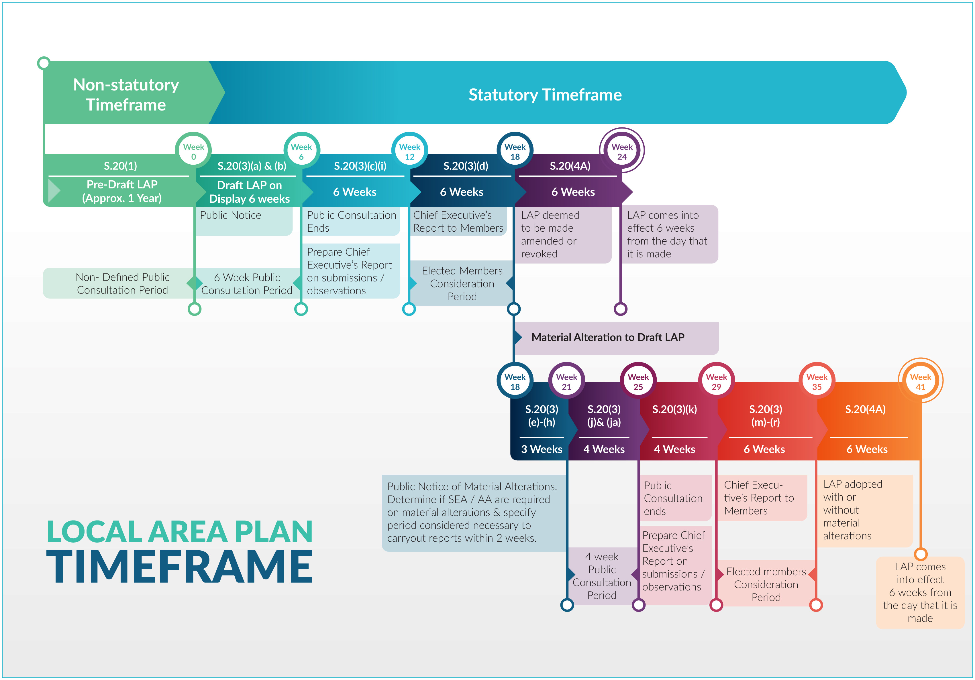
Each stage of the plan making process for a Local Area Plan is set out below (click to enlarge).
How did my ideas and views inform the Local Area Plan?
Your views helped shape the direction that the final Local Area Plan.
Your written submissions / observations were reviewed and summarised, and recommendations were made in response to them in a Chief Executive's Report.
This report was circulated to the Elected Members for their consideration in May 2025.
The Elected Members agreed to make the Local Area Plan, by way of a resolution, with minor amendments at a a Special Council Meeting on the 5th June 2025.
Thank you for taking the time to have your say in the process by making a written submission / observation and helping to shape the policy framework for your area.
Future Local Area Plans
How can I find out more information about the Draft Old Connaught LAP?
The Draft Old Connaught Local Area Plan was on public display from 6th March 2025 - 17th April 2025.
A recording of the webinar can be viewed here.
All Draft LAP documents are available to view online under the document list on this webpage, in our Virtual Room, the Council Offices in County Hall and Dundrum or in any of our dlr Library branches.
How do I make a submission?
Submissions or observations can be made in either of the following two ways:
-
online through our consultation hub here.
-
in writing addressed to Senior Executive Officer, Planning and Economic Development Department, Dún Laoghaire-Rathdown County Council, County Hall, Marine Road, Dún Laoghaire, Co. Dublin.
The closing date for submissions or observations is 23.59 on the 17th April, 2025.
What happens now?
All submissions made during the Draft Plan public consultation stage are now being reviewed.
A Chief Executive's report is being prepared which summarises the issues raised in submissions / observations received and will set out recommendations.
How do I make a submission?
Submissions or observations can be made in either of the following two ways:
-
online through our consultation hub here.
-
in writing addressed to Senior Executive Officer, Planning and Economic Development Department, Dún Laoghaire-Rathdown County Council, County Hall, Marine Road, Dún Laoghaire, Co. Dublin.
The closing date for submissions or observations is 23.59 on the 9th May, 2025.
Can I view a hard copy of the Issues Paper?
Yes. A hard copy of the Issues Paper can be viewed at the following locations:
- Dundrum Council Offices,
- County Hall, Dún Laoghaire, and
- In all dlr library branches.
Will the LAP change the roads in Old Connaught?
The Old Connaught Local Area Plan was informed by an Area Based Transport Assessment (ABTA).
The recommendations from this assessment have been incorporated into the LAP in the form of objectives that will facilitate future improvements to public transport, pedestrian movement, cycling provision and the road network in the area.
Local Area Plans
Can I still view the webinar recording?
The Draft Kiltiernan - Glenamuck Local Area Plan was on public display for a period of 6 weeks from 6th February 2025 - 21st March 2025 during this period an online webinar was held on Tuesday 18th February 2025.
A recording of the webinar can be viewed here.
Why do you spell Kiltiernan with an extra 'i'?
The Planning Authority uses the Tailte Éireann (OSI) / historical spelling of Kiltiernan in Local Area Plans (KGLAP). This was used in the previous Local Area from in 2007 and 2013.
Page 19 of the Chief Executive's report on the KGLAP Pre-Draft Consultation notes that the the spelling of Kiltiernan has varied over the years from as early as the 17th Century.
The Chief Executive's report includes a historical map of the area illustrating the 'Kiltiernan Domain' and 'Kiltiernan' place names on Tailte Éireann maps from the first edition of the 6inch map (1829-1841).
Contemporary mapping from Tailte Éireann retains this spelling if Kiltiernan.
How do I find my submission / response to issues in the Chief Executive's Report?
Volume I of the Chief Executive’s report summarises the issues raised in the Draft LAP chapter sequence together with the Chief Executives response and recommendation.
Volume II of the Chief Executive’s report summaries every submission and lists the persons who made a submission. Each summary contains a submission number, the person / organisation name (where provided) and the chapter of the Draft LAP to which the issues raised relate.
The easiest way to locate your submission is to search your name / organisation in Volume II (hold ‘Ctrl’ & ‘F’ together to open the search bar in the document). Take a note of the submission number, prefixed with the letter ‘B’.
Open Volume I and search this document using the relevant submission number. Note, that the submission number may be listed under more than one issue – use the next/previous buttons in the search bar to navigate to other issues as required.
You may also view your submission in full by clicking on the submission number within the Chief Executive’s report, alternatively, all submissions / observations made on the Draft Plan can be view online here.
How do I make a submission?
Submissions or observations can be made in either of the following two ways:
-
online through our consultation hub here,
-
in writing addressed to Senior Executive Officer, Planning and Economic Development Department, Dún Laoghaire-Rathdown County Council, County Hall, Marine Road, Dún Laoghaire, Co. Dublin.
The closing date for submissions or observations is 23.59 on the 21st March, 2025.
What is a Local Area Plan (LAP)?
A Local Area Plan (LAP) is a statutory document prepared by the Local Authority in accordance with the requirements of the Planning and Development Act 2000 (as amended).
A LAP consists of a suite of policies and objectives to guide the development of an area for a period of 6 years. A LAP sets out a land use strategy for the proper planning and sustainable development an area and consists of a written statement and maps indicating:
- objectives for the zoning of land for the use solely or primarily of particular areas for particular purposes, or
- other objectives in such detail as may be determined by the Planning Authority for the proper planning and sustainable development of the area to which it applies, including the objective of development of land on a phased basis and, detail on community facilities and amenities and on standards for the design of developments and structures.
How long is the public consultation period?
The pre-draft public consultation period runs from 12th September 2023 to 17th October 2023.
Where can I view the Dundrum LAP?
The Dundrum Local Area Plan documents can be viewed in full:
- on this webpage by expanding the 'Dundrum Local Area Plan 2023' banner.
- In the Dundrum Council Offices Mon-Fri (except bank holidays) 9:30am to 12:30pm and 1:30pm to 4:30pm
- County Hall Mon-Fri (excluding Bank Holidays) between 10.00a.m and 4.00p.m.
- Upon request in any dlr library branch. Details of each library opening times are set out here.
Can I speak to someone in person about the process?
There will be two information sessions where Council officials will be available to speak to in person. The information sessions are on the following dates:
- Thursday 21st of September 2023 at Kilternan Centre, Enniskerry Road, D18 ET99 from 4.00p.m. - 8.00p.m.
- Wednesday 11th of October 2023 at Kilternan Centre, Enniskerry Road, D18 ET99 from 4.00p.m. - 8.00p.m.
Can I view a hard copy of the Draft LAP?
Yes. A hard copy of the Draft Old Connaught LAP can be viewed at the following locations:
- Dundrum Council Offices,
- County Hall, Dún Laoghaire, and
- In all dlr library branches.
Who can I contact if my query isn't addressed here?
In the event that your query isn't addressed on this webpage, you can email us at: dlrforwardplanning@dlrcoco.ie.
How do I make a submission?
The submission period for the Draft LAP closed on the 21st July 2023.
In the event that material amendments are made to the Draft LAP, further submissions will be invited at that stage.
DISCLAIMER
The list of FAQs do not purport to be a legal interpretation of the Planning and Development Act 2000, (as amended) and are simply for information purposes.
Can I view the webinar recording and slides?
The webinar video is available to view on the Draft LAP webpage and on the dlr YouTube channel here.
The slides presented during the webinar are available to view under the Stages involved in the preparation of the Dundrum Local Area Plan list above or, the Draft LAP presentation can be viewed here and the ABTA presentation can be viewed here.
How long is a LAP in force?
A Local Area Plan is a 6 year plan, unless it is extended to 10 years.
Can I speak to someone in person about the Draft LAP?
Council officials were available to speak to in person during our drop-in days which took place in the Dundrum Council Offices on:
- Tuesday 27th June 10.30am – 12.30pm, and 2pm – 4pm
- Thursday 6th July 4pm – 8pm.
What happens now?
All submissions made during the Draft Plan public consultation stage are now being reviewed. Submissions / Observation can be viewed here.
A Chief Executive's report is being prepared which summarises the issues raised in submissions / observations received and will set out recommendations.
How did my ideas and views inform the Local Area Plan?
Your views helped shape the direction that the final Local Area Plan.
Your written submissions / observations were reviewed and summarised, and recommendations were made in response to them in a Chief Executive's Report.
This report was circulated to the Elected Members for their consideration in September 2023.
The Elected Members agreed to make the Local Area Plan, by way of a resolution, with minor amendments at a a Special Council Meeting on the 10th October 2023.
Thank you for taking the time to have your say in the process by making a written submission / observation and helping to shape the policy framework for your area.
Who can I contact if my query isn't addressed here?
In the event that your query isn't addressed on this webpage, you can email us at: planningsecretariat@dlrcoco.ie.
How do I make a submission?
The pre-draft consultation has now ended. Thank you to all who made a submission / observation.
There will be another opportunity to have your say during the public consultation on the Draft Local Area Plan.
How long is the public consultation period?
The Draft public consultation stage is for a period of not less than 6 weeks. This ran from Thursday, 8th June 2023 - Friday, 21st July 2023.
In the event that material amendments are made to the Draft LAP, these will be placed on public display with submissions / observations invited for a period of not less than 4 weeks.
Disclaimer
The list of FAQs do not purport to be a legal interpretation of the Planning and Development Act 2000, (as amended) and are simply for information purposes.
What happened after the Draft Plan public consultation stage?
After the public consultation, the planning authority prepared a Chief Executive's Report which was circulated to the Elected Members for their consideration.
The Elected Members then made the LAP, by way of a resolution, with minor amendments at a Special Council Meeting on the 10th October 2023. The LAP then came into effect, 6 weeks later, on Tuesday, 21st November 2023.
Each stage of the plan making process for a Local Area Plan is set out below (click to enlarge).
What happens now?
The Planning Authority is now in the process of preparing a Draft Local Area Plan for Old Connaught.
Once this has been completed, the Draft LAP will be placed on display as part of a statutory public consultation process.
DISCLAIMER
The list of FAQs do not purport to be a legal interpretation of the Planning and Development Act 2000, (as amedned) and are simply for information purposes.
Who can I contact if my query isn't addressed here?
In the event that your query isn't addressed on this webpage, you can email us at: dlrforwardplanning@dlrcoco.ie
What development is proposed in the Dundrum LAP?
A Local Area Plan does not contain development proposals, rather, it sets out policies and objectives to help guide any future development within an area.
A number of ‘site frameworks’ are set out in Chapter 2 of the Local Area plan that provide site specific parameters for future development.
All proposed development is subject to assessment by way of a planning application.
Will the LAP change the roads in Dundrum?
The Dundrum Local Area Plan was informed by an Area Based Transport Assessment (ABTA).
A number of the ABTA recommendations have been incorporated into the LAP in the form of objectives that will facilitate future improvements to public transport, pedestrian movement, cycling provision and the road network in the area.