Dún Laoghaire-Rathdown County Council (DLR) has been assessing the impact of the Covid-19 pandemic and identifying public realm and mobility interventions needed to safely reopen our county. DLR’s most recent initiative relates to ‘Coastal Mobility Interventions’, is aimed at promoting and facilitating a dramatic and necessary shift to walking and cycling along the strategic coastal transport corridor in our county. DLR is proposing to provide a new 3.6 km section of temporary, segregated 2-way cycleway from Newtown Avenue in Blackrock to Sandycove and the Forty Foot bathing area. This is being done through the reallocation of road space, by the introduction of a one-way system for vehicles, on Seapoint Avenue (N31), Queen’s Road, Windsor Terrace and Marine Parade. There will be a short 0.9 km section (Coal Quay Bridge to Queen’s Road) where cyclists will be able to use low-trafficked roads in Dún Laoghaire Harbour and then re-enter a segregated 2-way cycle route near to the Lexicon Library on Queen’s Road, and then continue on to Sandycove and the Forty Foot.
DLR’s design team is currently finalising the design details and engaging with stakeholders including the Gardaí, NTA, Transport Infrastructure Ireland, Dublin City Council Signal Traffic Control and the local community and businesses.
It is expected that works will start in early July 2020 and will take about 3 to 4 weeks to complete with certain phases of the temporary cycle route being opened earlier during that period as works are completed.
DLR is being supported technically and financially by the National Transport Authority (NTA) in implementing these interventions.
This set of critical mobility interventions is centred on making walking and cycling in DLR safe and enjoyable for all ages and abilities. This is in line with current Government public health advice where people are advised to walk or cycle if they can and to avoid using public transport unless they need to.
Covid-19 has had an enormous impact on our society. As we work towards reopening the county, we are presented with unprecedented challenges in terms of safeguarding public health and safety, ensuring safe and effective mobility and supporting the recovery of our local economy. DLR is working on getting the county reopened so that people can travel, work and go about their lives safely and with confidence as we emerge from this pandemic.
There has been a dramatic increase in walking and cycling during the pandemic, with a 100% increase in cycling recorded on coastal routes in May 2020, compared with the same period in 2019. There has been large increases in in the numbers of people walking and pedestrians are often faced with situations where there is not enough footway width to cater for the need to maintain 2-metre physical distancing, which can lead to people stepping off the footpath and potentially colliding with oncoming traffic. In addition, the profile of cyclists typically using the road is changing with cyclists of all ages and abilities now using the county’s roads, streets and cycleways. The increase in numbers of pedestrians and cyclists, together with an increase in average vehicle speeds on our roads, and the absence of dedicated or segregated cycleways on particular routes may present a significant risk to these vulnerable road users. Statistics from the Road Safety Authority for the year to date up to the end of May 2020 show that there has been a 9% increase in road fatalities on the nation’s roads for the first 5 months of the year compared to the equivalent period in 2019. Even more concerning is the doubling of the number of pedestrians killed on the country’s roads during that same period. This is despite a dramatic decrease in social and economic activity, and resulting vehicle journeys, which were as low as 30% to 40% of pre-Covid-19 traffic levels, over the period that the country has been dealing with the Covid-19 crisis.
The road safety risk is a matter of serious concern and DLR as a local authority and a road authority is of the view that it is now necessary to make an important intervention along these sections of coastal road to safeguard the health and safety of people walking and cycling in DLR, who are the most vulnerable road users.
Along with the public health and safety issues, a key challenge for DLR is to support and facilitate residents, workers and visitors to move efficiently, safely and in significant numbers within the county, and indeed outside the county towards the city centre and to other locations. Pre-Covid-19, public transport accounted for a large proportion of the modal split and provided a significant proportion of work, school and leisure trips. At present, because of 2-metre physical distancing requirements arising because of Covid-19, the DART and public buses are operating at approx. 20% capacity. In other words, 4 out of 5 people who would have ordinarily used public transport now have to find an alternative method or mode of transport. The road network will not be able to support these additional trips by car, as there is insufficient capacity in the network to accommodate a shift to the use of cars, so as to bridge the modal share gap caused by the reduced public transport capacity.
The provision of segregated cycling infrastructure will support safe and sustainable transport and critically will provide DLR’s citizens, the travelling public and visitors with a safe and reliable means of travel so as to ensure that the current limited public transport capacity can be prioritised for essential workers, those needing to complete essential journeys and people who don’t have or can’t use an alternative to public transport.
Businesses and the local economy have faced a very difficult time over this last 3 to 4 months and many have been closed for long periods of time, with some businesses having recently reopened and others planning to reopen over the coming weeks. DLR is very aware of the difficulties of local businesses and these interventions are also aimed at supporting those businesses reopening and the local economy, generally.
This is also an opportunity as a society to reflect on the use of public space and to possibly reimagine our use of, and relationship with, that space, so that we can reopen our society and county with renewed hope as we recover from the exceptional challenges posed by Covid-19.
The proposed interventions are part of a wider programme of planned interventions in the public realm and with mobility to meet the challenges presented by Covid-19. We are currently carrying out work in Blackrock Village to reconfigure the public realm to respond to Covid-19 risks, creating safer and improved facilities for walking and cycling but also enhancing the public space to provide not only safe but also inviting places that people will want to come visit, spend time in and enjoy, which is also crucial to supporting businesses as they reopen. DLR has similar plans for Dundrum and we plan to carry out Covid-19 public realm interventions there in July. We are also examining the need for Covid-19 public realm and mobility interventions in other towns and villages and at various locations throughout the county.
The Coastal Mobility Interventions
Outline
See separate schematic showing an outline of the proposed coastal cycleway route from Newtown Avenue to Sandycove.
By way of context, the proposed route forms part of the strategic DLR Cycle Network, starting at Blackrock Park/Booterstown Avenue and proceeding along the coast to Dún Laoghaire and on to Sandycove/Dalkey.
A number of sections of this cycle route are already in operation (Blackrock Park to Seapoint Avenue, The Metals, etc.). In order to provide a continuous, safe, high quality and attractive route along the coast from Booterstown to Dalkey (passing Blackrock, Monkstown, Dún Laoghaire, and Glasthule and Sandycove) DLR are proposing to install new temporary cycling infrastructure as follows:
- A 2-way segregated cycle facility on the coastal or north side of Seapoint Avenue starting at the Newtown Avenue/Seapoint Avenue junction, continuing to the Clarence Street (York Road)/Crofton Road junction.
- Cyclists will also have the option to use the existing shared path, adjacent to the coast, from Seapoint bathing area through to Dún Laoghaire.
- From the York Road/Crofton Road junction, cyclists can then enter the Harbour area across Coal Quay Bridge where they will merge with on-road traffic through the Harbour and re-emerge on Queen’s Road (near the East Pier and opposite the Lexicon Library). The traffic volumes within the road network in the Harbour are low and so it provides a safe and attractive route for cyclists wishing to proceed along the coast.
- As an alternative, cyclists can proceed, as they have always done, along Crofton Road, where it is necessary to maintain 2-way vehicular traffic to facilitate public transport and the efficient flow of vehicular traffic. There are a number of connections available for cyclists from Crofton Road through to Dún Laoghaire Town Centre.
- Once cyclists gain access to the 2-way cycle facility on Queen’s Road (also with easy access to The Metals cycle route) they proceed in a 2-way segregated cycleway on to Sandycove and the Forty Foot, with the cycle way provided on the coastal side of the road.
- The number and location of residential parking spaces along the routes will remain unaffected but parking along the coastal side of affected roads may be offset from the existing kerb to accommodate the installation of the cycling infrastructure.
- Other car parking spaces along the route will be retained except for a small number of standard car parking spaces which will be repurposed to provide additional disability car parking spaces and bike parking.
- Existing public transport, including bus routes and bus stops, will remain unaffected by the proposed cycling infrastructure interventions.
Attached are 4 No. visualisations or artists impressions presenting a vision of what the proposed coastal mobility interventions might look like at:
- Seapoint viewing area on Seapoint Avenue (N31)
- Queen’s Road near to the Lexicon Library
- Queen’s Road near to the the Lexicon Library (view with road temporary closed off to vehicles for markets or events)
- Potential use of ‘Pop-up Space’ on Marine Parade
The interventions will not only provide functional and improved pedestrian and cycling facilities but will, through placemaking and provision of planters, seating, etc., also provide attractive and welcoming public spaces.
The Design
DLR is using a dynamic and adaptive approach for the design and construction of the temporary cycling infrastructure, which is based on putting in place an accelerated work programme to get the infrastructure installed in as short a timeframe as possible. The initial design may be adapted as installation proceeds, which will allow us to tweak and improve the layout and infrastructure following its initial installation.
To facilitate the introduction of the 2-way cycleway facility a number of road layouts will have to be altered and traffic lanes reallocated to create this space. It is proposed to:
- Make Seapoint Avenue one-way for vehicles from Newtown Avenue to Coal Quay Bridge/York Road junction. Vehicles will travel west along this route (towards Blackrock). A small section of two-way road for vehicles will be provided from the West Pier Campus to Link Road (at the Purty Kitchen). This is to enable easy access to the homes and businesses, as there is there is no left turn allowed from Clarence Street onto Seapoint Avenue.
- Queen’s Road will be one-way from Park Road junction (at the Peoples Park) to the entrance to the Lexicon Library and Pavilion car parks (westbound towards Dún Laoghaire).
- Queen’s Road, at the Park Road junction, to Sandycove Avenue west will be one-way eastbound for vehicles, i.e. towards the Forty Foot. Again, the cycling infrastructure will be on the coastal or north side and eastbound traffic will travel on the south side of the road.
The 2-way cycle lanes will be segregated from vehicular traffic by kerbs and/or bollards (with some gaps for access to side roads/driveways, etc.) and a change or contrast in surfacing (buff antiskid) will be provided to further highlight the presence of the cycling infrastructure.
The Benefits
The provision of this proposed cycling infrastructure will enable people to cycle safely and efficiently in both directions along the coast and access areas like:
- Booterstown
- Blackrock Park
- Blackrock Village
- Seapoint bathing area
- Monkstown
- Dún Laoghaire Harbour
- Dún Laoghaire Town
- The Peoples Park
- Glasthule
- Sandycove and the Forty Foot bathing areas
- Dalkey Town
- Killiney Hill Park
It will also provide safe access for cyclists to schools, third level colleges, workplaces and businesses along the route, as well as connectivity with cycling infrastructure and mobility interventions in adjacent local authority areas, particularly those being carried out in the Dublin City Council area.
Census data reviewed as part of studies for DLR Cycle Network indicates that there are c. 5,000 students in Secondary school and 2,750 in 3rd level institutes within 500 metres of this coastal route. A large percentage of these students may have previously opted to use the DART or public bus to make their journeys, and so their options with public transport capacity reduced will be much more limited. The provision of a high quality, safe and attractive cycle route will provide students with a safe, sustainable and viable transport option to enable them to access their school or college.
The census data also notes that there are c. 10,000 people employed along the route and similarly a cycle route along the coast will provide safe and reliable travel options for those who need to travel journeys of typically 5 to 10 km to work, and also those who wish to connect with other modes of transport to complete their journeys.
Opportunities and Related Initiatives
The temporary cycling corridor presents a significant opportunity for local businesses and tourism. This will be enhanced by the promotion and development of cycling links to the towns and villages along the route. This will create strong and vibrant pedestrian and cycling links with Booterstown, Blackrock, Monkstown, Dún Laoghaire, Glasthule, Sandycove and Dalkey.
DLR is engaging with businesses in Dún Laoghaire Town Centre and examining the possibility of temporarily pedestrianising Georges St. Lower and Convent Lane, to facilitate safe physical distancing and create a welcoming environment for those living, working, visiting or doing business in the town.
DLR is also engaging with groups representing community, residents and business in the Sandycove and Glasthule area to look at enhancing the public realm, through the reimagining of public spaces, to help facilitate safe physical distancing and support businesses as they reopen.
It is proposed to close a section of Queen’s Road (between the Lexicon Library and Park Road junction) at weekends to facilitate the relocation of DLR COCO Markets which can no longer be held in the Peoples Park owing to Covid-19 physical distancing restrictions. The temporary closing of this section of Queen’s Road offers potential for a vibrant civic space for various events and activities.
There are a number of opportunities along the route for the creation of imaginative ‘Pop-up Spaces’. These are spaces where cycle parking, seating and planting can be provided at stop-off points on the cycling route or close to village centres. As well as providing rest areas, through the use of public seating, these can also facilitate local businesses who may not be in a position to have seating located directly outside their premises.
Walking and cycling is beneficial for our health and the environment involving aerobic exercise and enhanced health benefits such as combatting obesity, diabetes and heart-attacks, while both modes of transport result in negligible environmental pollution.
Traffic Impacts
The introduction of a one-way facility between Queen’s Road, from the Park Road junction and Sandycove Avenue West will not adversely impact traffic in the Sandycove and Glasthule area, as the direction of travel on all connecting roads between Queen’s Road/Windsor Terrace/Marine Parade and Glasthule Road will remain unaffected.
Under the proposals, traffic will no longer be able to access the Harbour car park closest to the East Pier via Queen’s Road (i.e. at the National Yacht Club) to avoid conflict with cyclists and pedestrians and instead access to all car parks within the Harbour will be facilitated from the Queen’s Road/Marine Road junction and via Coal Quay Bridge.
Traffic travelling east from the city that previously accessed Dún Laoghaire along Seapoint Avenue (N31) will have the option to use Monkstown Road where the journey distance is similar.
There will be no change to the direction of flow of traffic or existing car parking arrangements on connecting roads between Seapoint Avenue and Monkstown Road.
Traffic approaching from Newtownpark Avenue direction would no longer be able to access Seapoint Avenue (and currently cannot turn right onto Monkstown Road) and would have to turn off, further back in the road network, before reaching this point. The journey distance to Dún Laoghaire from Newtownpark Avenue at the Monkstown Ring Road is shorter via Monkstown Avenue than Seapoint Avenue, and this route and other routes further back on the road network, such as the N11, will be appropriately signed to encourage vehicular traffic to use it as part of the management of the proposed temporary mobility interventions.
Diverting this traffic earlier in the network will reduce any potential impact on Monkstown Village. Following the completion of the improvement works to Monkstown Village, Monkstown Crescent has been traffic-calmed and speed surveys show a significant reduction in speed of vehicles travelling through the village. While it is expected that there will be increases in volumes of through traffic on Monkstown, this will be monitored on a regular basis as the temporary mobility interventions are installed and become operational.
Another significant impact will be the very likely transfer of a significant proportion of cycling traffic off Monkstown Road onto a safer, and more desirable, segregated 2-way cycleway on Seapoint Avenue.
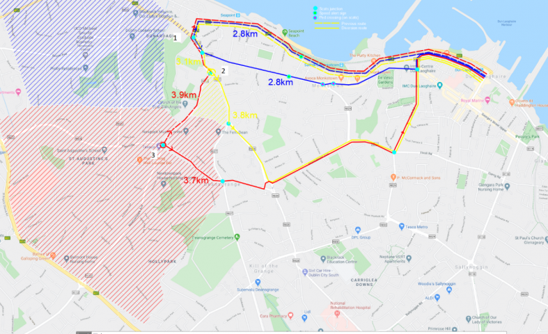
The above map shows differences in journey distance to Dún Laoghaire Town from various points following the introduction of the proposed one-way system for vehicular traffic on Seapoint Avenue:
- Traffic travelling from the city and residential traffic in around the blue hatched area have a similar distance to travel along Monkstown Road.
- Residential traffic from people living in the yellow hatched area will have a slight increase (3.1 to 3.8km). We would also note that these residents may use the cycle route when it is provided rather than chose to use a vehicle.
- Residents driving from the red-hatched area (and people located further out) have a shorter route as shown.
We will monitor traffic flow data that is measured continuously at signal junctions along these routes. There is also an extensive network of CCTV cameras that can be used to review any impacts on the traffic network. We will also be installing additional cycling and pedestrian counters. As the route changes are implemented and temporary cycling infrastructure installed, we will monitor the changes closely, and make any modifications or improvements that are deemed necessary.
Gallery